Anghai
Range
Anghai
Altitude
411m
Difficulty
Very difficult

Explore Offline
Download the app for 3D offline navigation, interactive trail maps, and emergency SOS tools.


About Anghai
Forts Anghai & Mrugagad: Near Jambhulpada (Raigad Dt.). Built to guard Savani Nisani routes and Amba River Valley. Expect few structures (built for watchkeeping). Location details: Anghai's base village Kalab is in Raigad Dt., but the fort/mountain range is in Pune Dt. Popular route to Lonavla. TREK WARNING: 4 rock patches! Bring technical gear and experts.
Best time to visit
Visit: Oct-Mar
Places to See
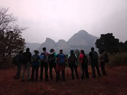
**Anghai Fort Trek: The Journey** Start at Anghai village. Spot three peaks; Anghai Fort is the one on the left.1. **Field Crossing (15 min):** Head through fields to the Amba River bridge. Look for the "Buruna Doh" tree on the left. 2. **Hill Climb (5 min):** Cross the bridge and ascend the tree-covered hill. Pass a Mango orchard and house. The path near the house leads to the pass between Anghai Fort and the peak to its right. 3. **Forest Trail (15 min):** Cross the orchard into a dense forest patch. Follow the trail to a flat ground, then through more dense forest. 4. **Cleft & Rock Patch 1:** Follow signs to the cleft between the peaks. Navigate a 15-foot rock patch (holds for grip). Bypass it on the right where the wall ends, using rock holds and trees. 5. **Cave & Steps:** After the patch, find a cave on the left. Rock-cut steps on the right lead to the base of the fort cleft. 6. **Cleft Ascent:** The ascend is steep (70-80° vertical) with fallen rocks. The path closes halfway; shift sideways to Rock Patch 2 (10 feet, 6 rock-cut steps, possibly buried). 7. **Upper Ascent:** It takes \~45 minutes from the first rock patch to the third. Continue in the cleft for 15 minutes to reach the pass between the fort and the hill on the right (dense forest). 8. **Summit Push:** Further up, find more rock-cut steps, followed by a final rock patch, leading to the fort top.**Fort Highlights:** Goddess Anghai temple and three water tanks. **Views:** Tail Baila and Sudhagad forts.
Journey & Transport
Time to Reach
3.5 hours from Kalamb village
How to Reach
How to Get There: By Road:1. Reach Khopoli. 2. Drive 29 km on the Khopoli - Pali route. 3. Take the diversion for Jambhulpada. 4. Drive 6 km from there to Kalamb village. Total Distance (Mumbai - Khopoli - Kalamb): 87 km.By Train & Bus:1. Take a train to Khopoli. 2. Board a bus toward Pali. 3. Alight at Parali village. 4. Take an auto-rickshaw to Kalamb village.
Facilities
- StayNo Accommodation
- FoodFood options nearby: Pali & Khopoli.
- WaterNo drinking water available.