Hampta Pass
Range
Pir Panjal Range
Altitude
4270m
Difficulty
Moderate

Explore Offline
Download the app for 3D offline navigation, interactive trail maps, and emergency SOS tools.


About Hampta Pass
Hampta Pass is renowned as one of the most dramatic "crossover" treks in the Indian Himalayas, serving as a natural corridor between two starkly contrasting worlds. The journey begins in the Kullu Valley, characterized by dense forests of pine, maple, and deodar, opening up to lush green meadows bursting with wildflowers. However, upon crossing the pass at 14,100 ft, the landscape instantly transforms into the arid, barren, and striking cold desert of the Lahaul Valley. Trekkers experience vertical rock walls, hanging glaciers, and panoramic views of 6,000-meter peaks like Mt. Deo Tibba and Mt. Indrasan.
Best time to visit
July, August, and September
History & Significance
Trade & Nomadic Route: Long before it became a popular trekking destination, Hampta Pass was a vital lifeline used by the Gaddis—tough, semi-nomadic shepherds. They used this corridor for centuries to herd their flocks of sheep and goats between the valleys, seeking high-altitude grazing grass (locally called Neeru) in Lahaul during the summer months. It was also an ancient trading route for locals moving grains, salt, and wool. • Mythological Origin: The pass derives its name from the tiny village of Hampta in the Kullu Valley. According to local lore, it is also named after Hampta Maharishi, a sage who meditated there. Furthermore, Hindu mythology suggests this route was traversed by the Pandavas on their quest for heaven, earning the trail to Chandratal the nickname "the staircase to heaven."
Places to See
Chika meadows, Balu Ka Ghera (Heaps of Sand), Shea Goru, Chatru, Chandratal Lake, and views of Mt. Deo Tibba and Mt. Indrasan.
Journey & Transport
How to Reach
To the Hub: Reach Manali, which is well-connected by Volvo buses from Delhi/Chandigarh (approx. 550 km from Delhi). The nearest airport is in Bhuntar (50 km from Manali). • To the Base (Start): From the Manali Mall Road area, take a taxi for a 16-20 km drive (about 1 hour) to Jobra. The motorable road ends here, and the trek begins on foot. • The Return: The trek finishes at Chatru in the Lahaul Valley. From Chatru, you will take a vehicle back to Manali, which usually routes through the modern Atal Tunnel (significantly cutting down travel time compared to the old Rohtang Pass route).
Important Notes
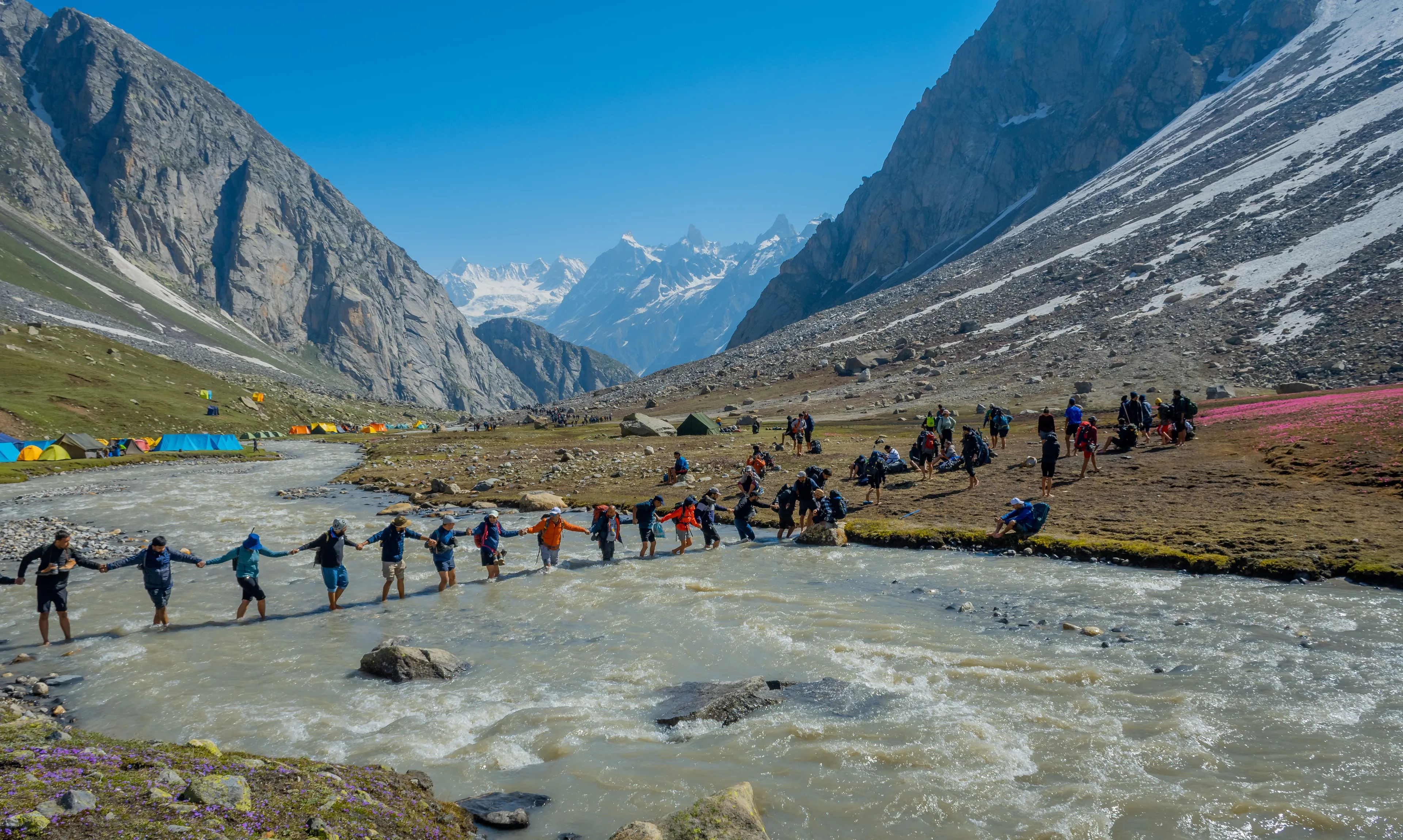
River Crossings: The trail involves crossing fast-flowing glacial streams, most notably at Shea Goru. This is always done early in the morning when the glacial meltwater flow is at its lowest, though the water is freezing. • Acclimatization: Due to the rapid gain in altitude, Acute Mountain Sickness (AMS) is a real risk. Proper hydration and adherence to acclimatization protocols are mandatory. • Gear: Mountain weather here is notoriously unpredictable. Temperatures can plunge below freezing at night. Layered clothing, waterproof jackets, and sturdy trekking boots are non-negotiable. Microspikes and gaiters may be required for snow patches near the pass. • Connectivity: There is absolutely no cellular network beyond Jobra. Make all necessary calls before leaving Manali. Mountain weather is highly unpredictable here. Altitude sickness is a risk; proper acclimatization is required. Trekking poles are strongly advised for the steep descent into Lahaul. Nearby police station: Manali Police Station Nearby hospitals: Civil Hospital Manali, Lady Willingdon Hospital (Mission Hospital) Manali
Facilities
- StayCamping in tents at designated sites (Chika, Balu Ka Ghera, Shea Goru, and Chatru).
- FoodBasic dhabas are available at the Jobra base; beyond that, all meals must be carried or prepared by a trekking team.
- WaterNatural mountain streams are available along the route. Carrying a reusable bottle and water purification tablets is highly recommended.